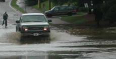

Remnants from tropical depression Alberto overwhelmed Raleigh residents with a constant downpour of rain Wednesday as the system made its way across the area.
Summer students and faculty trudged through standing water while motorists experienced heavy traffic. Flooding created problems not only for pedestrians with umbrellas, but for the Wolfline as well.
According to Transit Manager Starr Wimberly, the shuttle and village link routes of the Wolfline were rerouted off of Sullivan Drive. She said the Fraternity Court route was also altered due to the storm.
Christine Klein of the transportation department said she was optimistic about resuming normal services late Wednesday.
“Everything should be fine by the afternoon,” she said.
During the morning flooding, Klein commented that the most affected campus roads were parts of Sullivan and Thurman Drives.
While the transportation department worried about the affects the flooding would have on the bus service, students tried not to get their shoes soaked and faculty members took the opportunity to brandish Wolfpack embellished umbrellas.
Allen Daeke, assistant director of utility services, commented on the massive clean up that his department encountered.
“We have responded to over 100 calls,” he said. “There was flooding in the 1911 building; the grounds keeping staff is cleaning it out.”
Daeke mentioned the aftermath would take a while to completely clean up.
“Carpet crews will be working into the night,” he said.
Tropical depression Alberto left its mark on the greater Raleigh area as well. Major streets near campus, such as Gorman and Avent Ferry, were also flooded, prompting Raleigh Police to stand by near several streets.
The Carolina Hurricane’s Front Lawn Party was not open for Wednesday’s game, and fans were not able to watch the fifth game on the RBC Center’s South Lawn because of the amount of rain accumulated from Alberto, according to Dave Olsen, vice president and general manager of the RBC Center.
Tracking the storm
“It’s interesting that we had activity this soon again this year,” Barrett Smith, graduate student in marine, earth and atmospheric sciences and research assistant for the State Climate Office, said.
He added that June is usually a quiet month for hurricane activity, but doesn’t know if this year will be a repeat of last year’s record 26 storms.
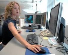
According to Mike Strickler, meteorologist intern at NWS on Centennial Campus and alumnus of the University, there are several different ways to track tropical depressions.
“Satellite data [is] the most useful,” he said. “Satellites way out in space and those are very helpful because our radar, which is another way of tracking tropical systems, only works over land because of course you can’t put a radar out over the water.”
Radar is restricted to 100 miles off the shore of the coast, so beyond that the best way to track tropical systems is by satellite imagery, he said.
“Then we’ve got surface observations,” Strickler said, that measure winds, temperatures, pressures and dew point temperatures. “We’ve got those located all across the continental United States.”
Sensors measure pressure and, because there’s lower pressure with tropical systems and the winds around systems rotate counter clockwise into the lowest pressure, forecasters can find where the center of lowest pressure is.
From their data, forecasters can predict the track of the tropical depression, the intensity and how much rain is going to be produced for a given storm.
Forecasters also use computer models, which are models of the atmosphere, and plug in data from the surface observations into the model. From the data, the model predicts the forecast.
“There are a bunch of different models out there and each one gives you a different solution, so it’s our job as meteorologists to figure out which model looks the most reasonable,” Strickler said.
The National Hurricane Center, located in Miami, Fla., is in charge of issuing all of the guidance for tropical systems. Once the systems make landfall, the hurricane center coordinates with surrounding weather offices, like the National Weather Service in Raleigh, and those local offices use the guidance and tailor that to local areas.
In terms of predictions, there’s still a lot of uncertainty, Strickler said. He said tropical depression Alberto was forecast to remain a fairly minimal tropical depression, but it intensified rapidly and almost reached hurricane status before it made landfall.
“That wasn’t that well forecast. It’s just beyond the state of the science at this time,” he said. “We do the best we can with those observing systems.”
Strickler said a possible explanation for forecasts gone wrong is the chaos theory, referring to the idea that a butterfly’s wings might create tiny changes in the atmosphere, but said models offer a better explanation.
“Models are more accurate in the short term, say 24 hours, than they are in, say, seven days because errors in the models amplify with time,” he said. “As you get farther off in time, the track of the storm’s going to be way off. That’s just a function of the time.”
With tropical depression Alberto, it is believed that it strengthened overnight as it passed over the loop current, a warm ocean current in the Gulf of Mexico that flows northward then loops east and south before exiting through the Florida Straits.
Hurricanes need that warm water to thrive and gain intensity, Strickler said, adding that that is hypothesized to have contributed to the strengthening of tropical depression Alberto.
Ryan Boyles, associate state climatologist for the State Climate Office and doctoral student in marine, earth and atmospheric sciences, said in an interview on Tuesday afternoon that Raleigh will probably not suffer any damage from tropical depression Alberto.
“We really don’t know,” he said. “It’s still a ways out. It’s not expected to intensify dramatically and it might bring us some actually much-needed rainfall.”
Boyles said tropical depression Alberto would probably start affecting the Raleigh area on Thursday morning, citing the latest advisory warning at the time that it was expected to move out to shore during Thursday and into Friday.
The later reports, however, predicted tropical depression Alberto to move out to shore Wednesday, reaching off the coast of Maryland by 2 p.m. Thursday, illustrating the unpredictability of the storms.
Smith said he wishes forecasters knew why hurricanes and tropical storms are so unpredictable.
“There are so many factors that control the strength of tropical storms and hurricanes,” Smith said.
“Sometimes if the track is misforecasted, then the hurricane may hit land before it turns into a hurricane…and therefore weaken, or it may go over waters that are cooler and therefore, not strengthen. There are so many different factors,” he said.
How forecasters make predictions
“Even before a storm begins to intensify or even before a storm…we can have an idea of locations favorable for development,” Strickler said.
Persistent thunderstorms developed from the warmth and moisture of the ocean during late summer and early fall, coupled with high winds, lead to the formation of a tropical depression and, if winds reach 75 miles per hour, a hurricane will form.
“Once the storms and showers do intensify and start to spin, you get a little better handle on where it’s going because again, you can input that data into the model to use to do the forecast,” Strickler said.
Smith said tropical depressions typically hit land in Florida and make their way up to Raleigh.
“A lot of times they’ll hit the coast in the Gulf and once they hit the Gulf, they will begin to drift to the northeast,” Smith said. “So, a lot of times they’ll either come straight up through the state or right along the coast, and their track is a big factor of whether we’ll get rain or not.”
Referring to the record-breaking number of storms from last year’s hurricane season, Smith said it might have also been a record for category three, four and five hurricanes.
“I don’t know that just because we have one already this year means that we’re going to have a record amount again,” he said. “I don’t think we know enough about hurricanes to say that.”